 |
| The view back up the valley toward Bhulbhule |
My watch alarm went off at 6:00am, but I was in such a sleep
that I barely heard it beeping. Sam
grunted from inside his bag, so I knew he was partially awake and I didn’t need
to throw something across the room at him as a gentle wake-up nudge. We were both rather slow getting up and moving
and my body was pretty stiff. After an
application of arnica gel to various parts of my legs and shoulders I gingerly
made my way down the spiral staircase for breakfast at 7:15am. Oh, that staircase…my legs were not thrilled to have to climb up and down them this morning. I may or may not have crawled up the steps on
my hands and knees after breakfast…shhh, don’t laugh.
 |
| Not a flattering photo, but...day three! |
 |
| Our hotel |
We had ordered the night before and asked for a 7:15
serving, but the food was a no-show until 7:30 or so – happily, the outside
patio table was a pleasant spot to watch the village come alive. I ate a chocolate pancake that was more like
a dense cake that I had to cut into wedges and then picked the pieces up with my
fingers to eat, sans butter or syrup or anything. Sam had ordered the “Set Breakfast” and the
plates of food flowed out of the kitchen so numerous thought they’d never
stop. Note to self: order the set
breakfast next time.
 |
| Sam's Set Breakfast |
 |
| My Chocolate Pancake |
As we ate, it started to sprinkle rain and the teahouse
owner rushed out quick as a flash and set up an umbrella over the table, so we
didn’t have to gather our plates and eat inside the kitchen. We could see large dark lightning clouds
rolling up the river valley towards us and heard the rumble of thunder, so we
didn’t hurry to hit the trail. The wind
picked up as we finished eating, so the umbrella was returned to the kitchen
along with our empty dishes; we took refuge on the second floor balcony as the
rain began falling with more energy than I thought necessary. It was a magnificent storm.
 |
| Before the storm became too fierce - Johnathan brushes his teeth |
I spent my time making sure all my gear was sorted in my
pack so it wouldn’t get wet; by 9:15 the storm had swept up the valley past us
and Sam and I decided it was time to leave.
We would be walking in the direction the clouds were traveling, but they
were flying much more swiftly than my sore legs would be able to propel my
pack-laden body. The rain had abated to
a mere drizzle as we left the Peace Full Hotel and by the time we reached the
edge of the village the rain had turned into mist. I kept worrying that we would get wet and cold,
reverting to my Alaskan fear of wetness that causes hypothermia, but this is
Nepal and though I got a bit wet, I stayed relatively warm and
dried off in no time.
 |
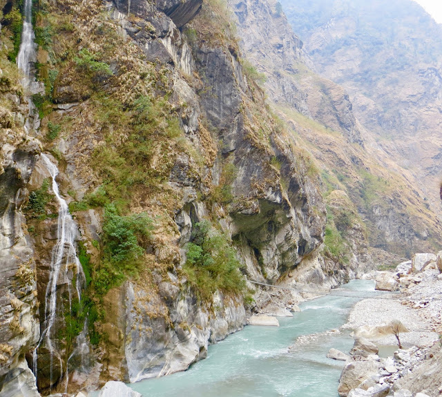
| The mist rising from the forest jungle, post rainstorm |
The damp ground meant that there wasn’t any dust, which was
a mercy. We left the road and followed
the red and white paint marked trail into the woods and began climbing the
jungly hillside that was teaming with banana groves and ferns. There was a frothy stream that flowed and
cascaded down the side of the trail as we switch-backed our way further up into
the dense green growth. That stream had
to be crossed several times by some extremely slippery log bridges, but they
only added to the fun of the trail.
 |
| Need to teach Sam how to take better photos. |
 |
| Super slippery rocky trail |
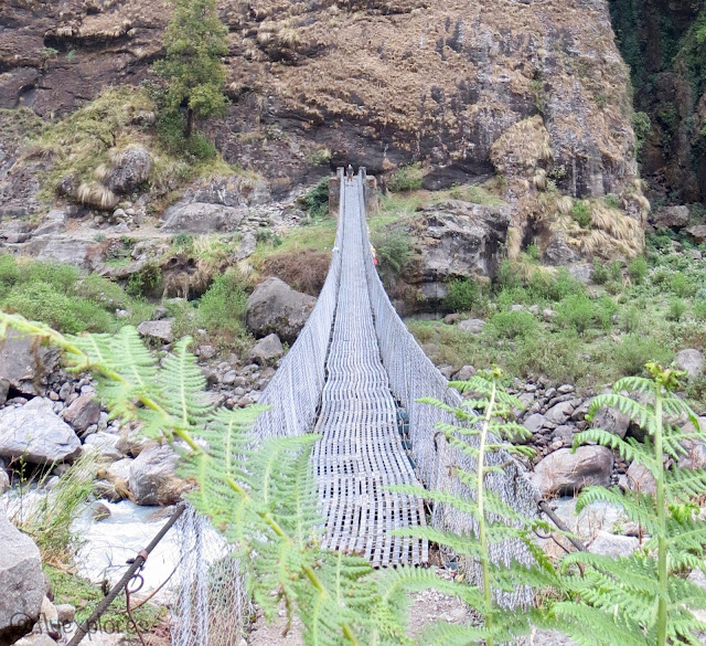
Eventually the trail descended back down to the road for a
short time before meeting a suspension bridge that spanned the mighty
Marshyangdi river.
Once across the blue water and on the other side of the valley, the cliffs rose steeply and the
trail climbed up, up, up severely.
We
were headed to Tal, so the painted signs and markers told us; this is where we
intended to eat lunch.
Each trail marker
persistently pointed up and seemed oblivious to my horror at such a never-ending incline.
I took small steps
as a strategy to not get winded (which worked), but my muscles were less than
pleased at the incessant climb.
 |
| Killer stone steps |
 |
| A typical road through a typical village |
 |
| Suspension bridge |
 |
| "Way to Tal" |
 |
| Ruins along the way |
 |
| So much up |
The ridgeline trail appeared to actually be a cattle trail –
proven by the encounter with cows further up the trail. They were lazily eating and cooling their
hooves in a mud puddle in the shade of a rock ledge, blocking the trail and not
giving us a care in the world. We had to
squeeze around them: remembering to pass them on the hill side, rather than the
cliff side, so as to not get knocked off the ledge if the animals got
frisky. Happily, they remained placid as
we navigated in between their fly pestered bodies as inconspicuously as we
could manage with our cumbersome backpacks.
By 2:00pm we crested the final hill leading into Tal.
A military post was perched up top there,
with barbed wire and everything.
I was
so pleased to have finally made it and the gate at the top was so cheery that
we couldn’t resist the photo-op.
It was
a rather hurried one though, because as Sam was snapping photos, a guard came
out and started yelling at us.
Whoops!
Apparently, they are not
willing to have happy tourists taking innocent photos near their
encampment.
We didn’t linger to see if
the guard wanted to talk to us, but scurried down the hill towards Tal.
The valley into which we descended was wide
and flat, with the road up on a ledge in the cliff face and the village of Tal
at the opposite end of the valley.
It
looked as if the river moves around in the riverbed, like so many rivers do
back home: changing course, bending all over the place, and moving back and
forth to create a wide, waterless riverbed.
Small river rocks and sand, coupled with the flat ground made for easy
walking as we neared the village.
 |
| Tal |
Once there, we decided not to stop and have lunch, not for
lack of decent places to eat, but because the sun was shining, the weather was
relatively mild, and we were feeling pretty good. Stopping for lunch would mean stopping for an
hour or more: the food is not ready ahead of time, but rather is prepared and
cooked after it is ordered. Hot drinks
and meals are heated by fire, which takes time to heat; should a person order a
dish with chicken in it, the chicken, in all likelihood, must first be caught,
killed, plucked, and then cooked.
Seriously. The only fast food
around here is when the food is still alive and breathing. This fact partly influenced to my decision
to eat primarily vegetarian. But, I
digress. We were feeling pretty good
physically, but also under a bit of pressure to make up for the time we lost
with our late start due to the rain and lightning of the morning and my
guidebook said we were four hours away from our destination for the night.
 |
| Tal is a calm and peaceful village |
 |
| Woman working in her garden |
Going into and out of Tal, we encountered our first set of
prayer wheels. I found them intriguing
and entertaining. As I understand it, a
person must pass them on the right side and spin the wheels as they are passed. Sam declined the activity, but I gave it a
try. We stopped to stick our fingers in
the blue river to see how cold it was and found it to be cool, but not
cold. Then, the trail began to climb
again as we left Tal behind us and made our way along the edge of the cliff.
 |
| They're fun to spin! |
 |
| Testing the water |
Much of the trail was simply a ledge carved into the face of
the steep cliff side of the valley wall.
The steps were really just a part of the rockface. Sometimes, there were gaps in the trail that
had been filled in with dry stacked rocks to make up the empty spaces. These were nerve-wracking to cross. What if they gave way? The trail itself was harrowing enough, with
its sudden drop-off ledge, without the added reminder of these mystery gaps in
the trail. One bright and unexpected
find along this part of the trail was the presence of dozens of orchids. The cliffs were lined with them, growing in
their natural habitat and blooming their heads off. I fought the urge to pry one from its rocky
roost and smuggle it back home in my backpack.
 |
| Ignore the tree...How did they build this??? |
 |
| Orchids! |
We stopped and ate a makeshift lunch with the snacks I had
in my pack: dehydrated bananas, rhubarb fruit leather, jerky, and a snickers
bar. The fuel was needed because there
was yet another steep incline to ascend.
I took off my shoes and removed the liners so things could dry out a bit
– my feet are not used to hiking in hot weather and sweat profusely. The 100 rupee bill and 100 dollar bill I have
stashed in each shoe, under the insoles, were beginning to look a little
shabby, but I like the insurance of having some hidden cash in the event that
we are mugged or somehow lose all our other money. So, I dried everything out as best I could
while we ate and then we packed up and braved the cliff.
 |
| See me with my red backpack up on the trail? |
 |
| Look closely to see the trail and the suspension bridge |
Other adventures awaited us as we trekked further into the
valley. We played for at least ten
minutes on a very long suspension bridge – making it bounce up and down and
taking photos. The other trekkers we had
been leapfrogging all day had already passed us, back when we were eating, so
we had the bridge all to ourselves.
Later, we overtook a herd of goats by a sign warning us to be on the
lookout for animals on the trail, as well as a sign informing trekkers of the
distances between villages.
 |
| See Sam across the bridge? |
Eventually, we had to resume road walking, because landslides
had wiped out the trail (see, I had legitimate cause to be concerned about the
hazards of the trail).
There were a lot
of waterfalls throughout this section.
A
couple of them fell onto the road and we got a little wet while passing them, but
by this time, I’d lost my fear of getting wet, since the sun was baking my
body.
The wind was a bit forceful and
constantly in our face since we had left Tal, but we made good progress
nonetheless and only two Mahindras, stuffed with people – arms, legs, and heads
sticking out of every window – and piled high with baggage and even more
passengers riding on the roof, rumbled past us on the road.
 |
| A Mahindra bumping up the road |
 |
| So many rocks! |
Then, we came to a historical demonstration of suspension bridges: a “new” bridge build right next to an ancient and dilapidated bridge - its cables twisted and a few remaining wooden planks clinging for dear life so
as to not drop into the gushing waterfall and river far below us. I suppose it was easier to just leave the
pitiful old bridge and let it naturally decay, but it felt as if it had been
left on purpose: for the education and entertainment of bridge traveling
passerby.
 |
| Rural Nepali life |
Across the river was a village, which we discovered, much to
our amazement, was Dharapani. Our
destination village had been achieved two hours earlier than intended! Since it was only 4:00pm, we wandered through
the length of the blue and gray village with its mud and stone paved roadway,
just looking at the people and the buildings and the jaw droppingly beautiful
mountains bordering the valley. Then, we
backtracked and checked in at the ACAP office and received our stamps in our
little paper trekker books. We
backtracked even further to a teahouse where we had seen the Israeli girl enter
as we passed – we had been leapfrogging this girl all day, so we decided we’d
stay at the same place as she was and get to know our trail fellows. The room we got had an attached bath for 500
rupees. I’m all about that attached
bathroom now.
 |
| Touring the town |
At 6:00pm we were in the dining room: a separate little
building with windows for walls and long wooden tables and benches for dining
and lounging guests. The kitchen was
attached to this, at the back, from which issued all manner of clattering and
banging – the cacophony of a busy kitchen.
I ordered Dal Bhat and then went outside to the grassy courtyard to send
my anxious mother a SPOT track and enjoy some air. There were some chickens in the yard –
probably someone’s dinner in feather form – and one appeared particularly
parched, so I poured out a bit of water from my Nalgene for the hen. She was snobby and refused my offering, so,
offended, I returned to the dining room to visit with more amenable companions.
Our two trail buddies from yesterday saw me as I was
crossing the yard, so they got rooms at our place as well. We all gathered in the dining room and
partook of great quantities of Dal Bhat, except Sam, who had that fried rice
stuff again. Our group of diners
consisted of three Americans (us and Johnathan), the Japanese girl, the
leapfrogging Israeli, a loquacious Brit, and a smiling guy from Indonesia. It was a nice evening spent sharing stories,
looking at trail maps, and discussing the trail. Strange how we can spend all day on the trail
and not tire of it even in the evening, as it is ever present in the forefront
of our thoughts.
It is now 8:30pm and Sam is in his bag reading from his
Kindle and I am likewise cocooned in my own bag, so very ready for sleep. Upon taking off my liner socks in preparation
for getting into my bag, I discovered I have two blisters on my right
toes. They aren’t bad, so I’m not too
worried. However, cramps plagued me
today and I’m hoping they don’t follow me into the night, as I desperately
would like to sleep through till morning.
Data
Starting elevation: 4,265ft
Ending elevation: 6,233ft
Distance: 9.7 miles
Weather: Rain, sun, warm, windy


